

 Back
hike
Back
hike
Refuge d'Avérole - Discover an authentic valley with your family

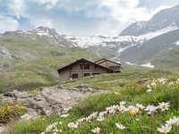
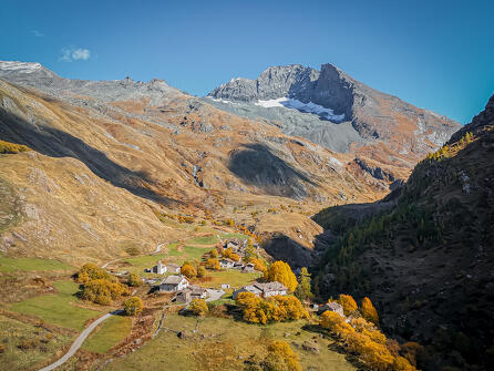
At the edge of the Bessans plateau, the green Avérole valley opens up, overlooked by the impressive blue-tinged Charbonnel Glacier.
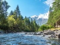
A picturesque trail winding through meadows and mountain hamlets, past oratories and chapels along the Avérole stream.
Description
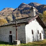
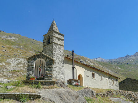
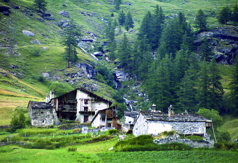
You enter this picturesque setting through the hamlet of Goulaz, then Vincendières, and finally Avérole. These typical mountain hamlets, with their stone, slate, and wood chalets, bear witness to a pastoral life that was once vibrant. Far from the village, the chapels and oratories bear witness to the fervent faith of the mountain people. Note that the Chapel of Saint-Pierre d'Avérole is listed as a historical monument.
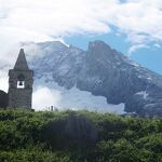
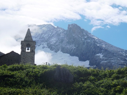
From the refuge, you can see the impressive peaks, all of which are over 3,000 meters high. The Pointe du Charbonnel (3,752 m) is the highest point in the Alps.
A timeless valley where many scenes from the "Belle and Sebastian" films were shot and where peddlers once followed the route to neighboring Italy.
Shuttle bus service available between Bessans, Vincendières, and Avérole in summer.
Additional welcome
The Avérole refuge has been awarded the "Refuge en Famille" label. You must book your overnight stay at the refuge in advance. Stay on the trails and follow the signs, and take your trash with you.
Environments
-
 Waterside
-
Riverside
-
Mountain view
-
Mountain location
Rates
Free access.
Itinerary
-
 Distance
14.6 km
Distance
14.6 km
-
 Route type
LOOP
Route type
LOOP
-
 Elevation gain
751m
Elevation gain
751m
-
 Negative gradient
751m
Negative gradient
751m
-
 Roaming time
2 days
Roaming time
2 days
-
 Signposted itinerary
Yes
Signposted itinerary
Yes
-
 Beaconing accuracy
Yellow blade markings.
Beaconing accuracy
Yellow blade markings.
-
 Nature of the land
Stone,
Ground,
Not suitable for strollers
Nature of the land
Stone,
Ground,
Not suitable for strollers
-
 Maximum altitude
2200m
Maximum altitude
2200m
Opening period
This route is accessible outside of snow season and is subject to favorable weather conditions. Check the local weather forecast in real time up until the day of departure.
Additional opening
-
Subject to favorable weather
-
Subject to snow conditions
Spoken languages
-
 French
Location
When leaving Bessans, turn right just before La Bessanaise toward Avérole and park at the Parking des Vincendières.
To get there by bus: take line 3 to the Parking des Vincendières stop. For more information, see the HMV mobility guide.
Documents


Animals
Pets allowed : Yes
Pets allowed with supplement: No
Pets are allowed under certain conditions. They must be kept on a leash on the trails and/or in the presence of herds or hikers. They are allowed in the shelter.
Guidebook with maps/step-by-step
-
1/ At the hamlet of Les Vincendières, turn left along the Avérole stream.
the path that leads just before the hamlet. The sound of running water in this mountain valley will accompany you on your walk, just as it once did the peddlers, who went from house to house selling their wares on their way to Italy. Pass through the hamlet of Avérole; this valley was not always so depopulated. Look around you and you’ll see traces of the old, bustling agricultural life everywhere!
Who built the dry-stone wall that makes the path between the hamlets safe?
Who prayed in the oratories and chapels that dot the route? Who lived in these houses with their typical mountain village slate roofs?
The valley’s many inhabitants of yesteryear have left their mark.
Follow the trail on the left to the foot of the refuge (after 20 minutes on a steep path). It’s here, facing the Pointe du Charbonnel (3,752 m), that you’ll spend the night. Keep your eyes peeled, as the surrounding peaks all rise to over 3,000 m!
2/ This morning, if you're feeling up to it, why not push a little further to explore this wild valley. It would be a shame not to climb up to the "Pas de la mule", skipping across the streams, before descending into the valley on the left bank of the torrent at the shepherds' hut.
If you're tired, you don't have to take the detour via the "Pas de la mule," but can cross over to the left bank via the bridge below the refuge parking lot and make your way gently back down to your starting point.


-
Distance
14.6 km
-
Roaming time
2 days
-
Elevation gain
751m
-
Negative gradient
751m


-
Bessans
 cultural heritage
Saint-Pierre chapel
- 15th C
-
Bessans
 cultural heritage
The hamlets of Bessans
-
Bessans
 hike
hikeA 2-day hike from the Refuge d'Avérole...
- Distance 4.5km
- Daily duration 01h45
- Elevation gain 366 m
-
Bessans
 hike
hikeA 2-day hike from the Refuge d'Avérole...
- Distance 10km
- Daily duration 03h45
- Elevation gain 384 m
- Elevation loss 770 m
-
Bessans
 trade and service
Parking des Vincendières